GPSLog Labs Blog

GPSLog Labs Blog

New features and tips for using gpsloglabs.com

Updates for September 26th

It's been a long time since I've updated the blog, but that doesn't mean nothing has been going on. Here are a few recent updates to GPSLog Labs:

  • Colour scheme update — hopefully this one is pretty obvious. Let me know if you find any remnants of the old colours or aspects of the new scheme that aren't working.

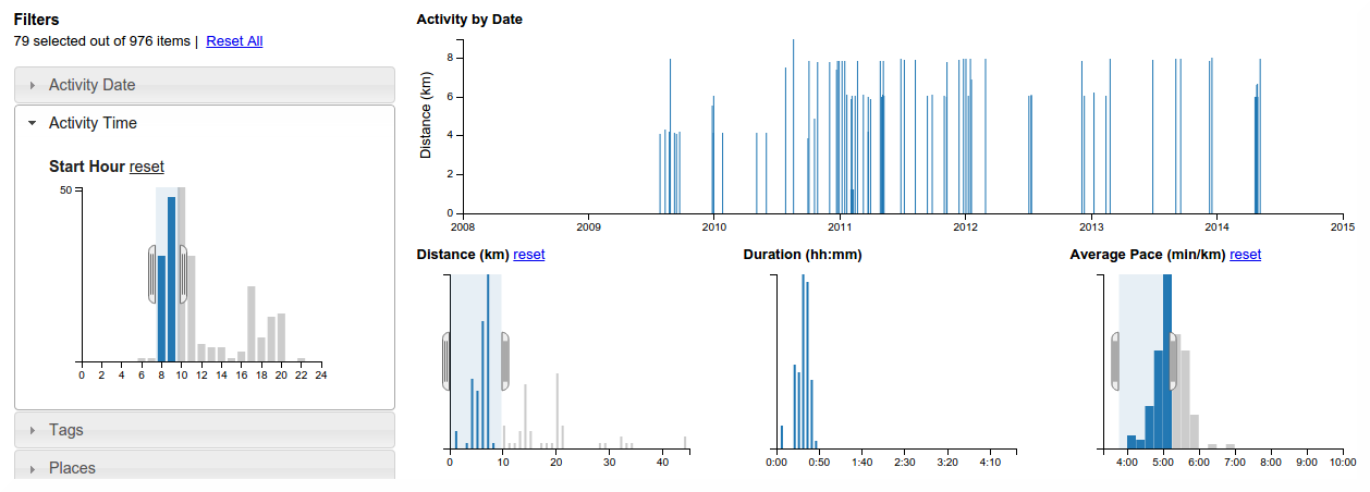
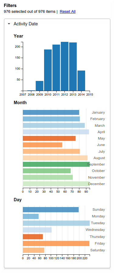
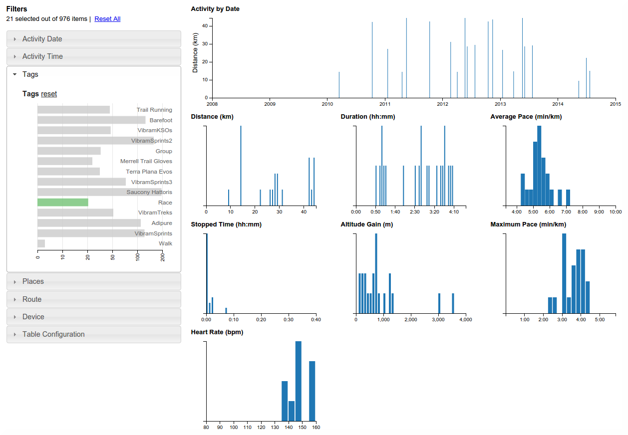
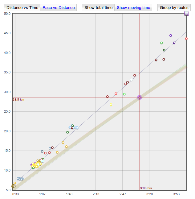
  • Tag crossfilter tab — This one is pretty neat. It uses the crossfilter library to provide an interactive exploration of the activity for a tag.

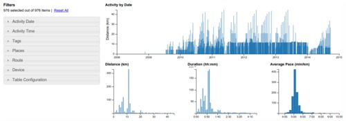
    You can click or drag a range of values on any of the charts and it will drill down and update all of the other charts and histograms immediately based on the new selection.

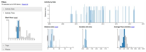
    Filters are available for many parameters, such as the date and time of the activity, the places and routes involved.

    This is a great way to answer a bunch of questions about your activity, such as:

    • when was the last time I ran route X faster than 5:00 min/km?
    • how many times have I run more than 30km?
    • what routes do I ride on weekends?

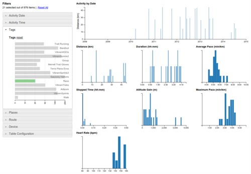
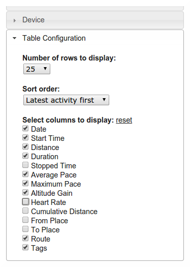
    The table at the bottom of the page shows the details of the selected activity and you can click through from there to the activity detail pages.

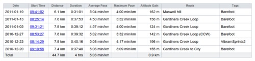
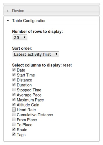
    The columns can be switched on and off too, which is handy if you've filtered in such a way that the places or routes are not interesting and just wasting space.

    There are still a few rough edges, so expect some improvements to this page as time goes on and it will be available in other areas of the site soon too.

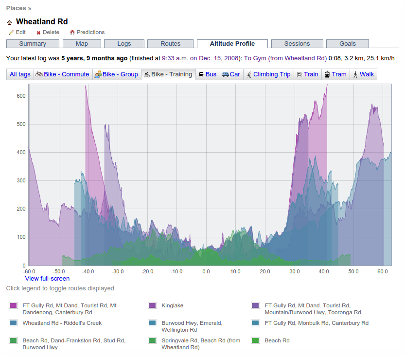
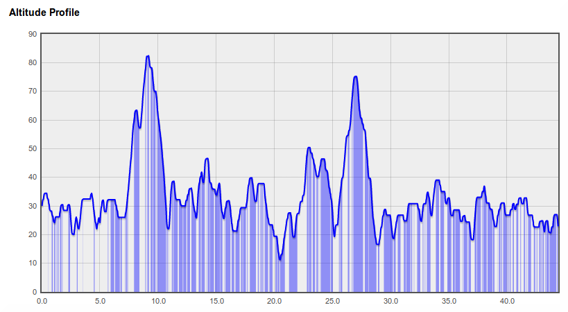
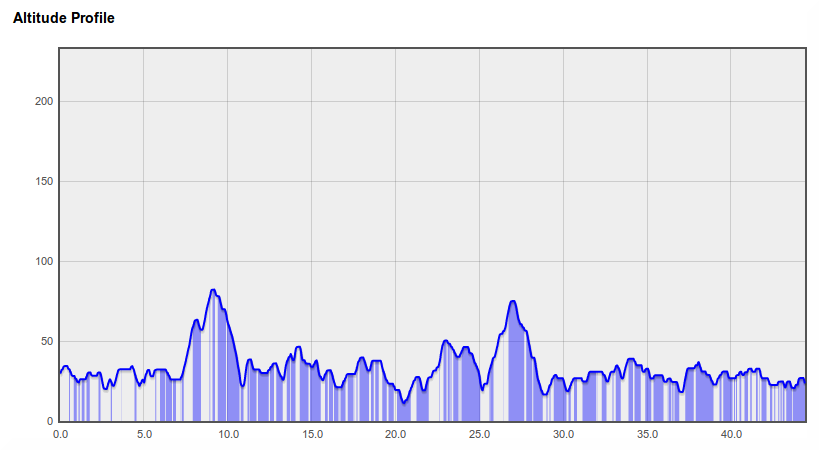
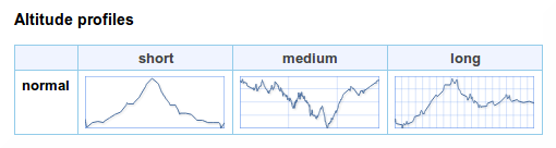
  • Place altitude profile tab — a semi-useful visualiation of the altitude profiles of routes to/from each place.

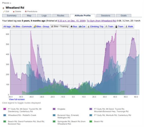
    The place is at the 0km point, incoming routes are to the left, outgoing to the right.

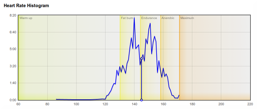
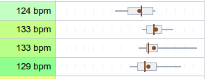
  • Added grid divisions to box whisker plots to help judge scale (15 sec increments for pace, 2.5 km/mile per hour for speed, 5 bpm for heart rate).

  • Changed goal tasks iCal file to output all day events. This is a bit less convenient in the calendar, but it avoids timezone problems.

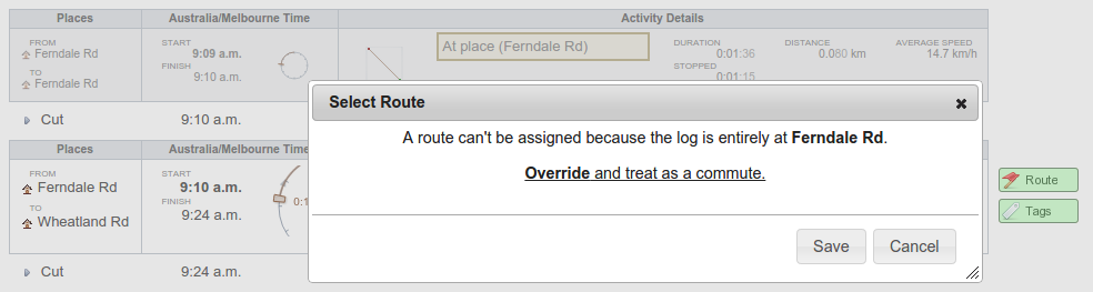
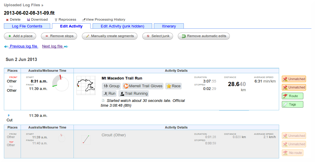
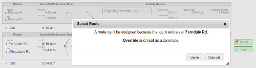
  • The "At place" flag on a segment can be overridden if necessary. Click on the "At Place (x)" and click "Override and treat as a commute".

  • Fixed auto-detect timezone button and a bunch of other little bugs.

Filed under  //  changelog   crossfilter   graphs   places  

Updates for December 17th

Some recent updates to GPSLog Labs, just in time for Christmas:

  • GPSLog Labs now has a public catalog of shared logs.

    By zooming in on a region of the world map, you can see activity other users have shared and use it to plan your runs, rides and hikes.

    You can still choose to keep your activity entirely private, or share it with a specific group of people, but if you want to include your activity in the catalog, simply go to your shared content, edit the activity you wish to share, and tick the "Include in Public Catalog" checkbox.

  • You can also now download shared activity as a GPX file which can then be loaded onto your device for navigation when you're out and about.

  • The route detail, route split detail and selection detail pages are now using a layout with a panel on the right hand side to better use the space on wider screens.

  • Editing notes in the side panels now saves your changes without reloading the page.
  • Also, I fixed a bunch of issues unfortunately introduced by the new dynamically loaded tabs. Apologies if you noticed things that weren't working properly for a while, and if you have any other issues, please let me know.
Filed under  //  changelog   routes   sharing  

Updates for November 10th

Some recent updates to GPSLog Labs:

  • When filtering a log file using a time or position filter, you can now copy nearby waypoints, rather than drawing the line each time.

    Once you zoom into/select the area to be filtered, click the "Search for nearby waypoints" button.

    This will list all the nearby waypoints and you can click on them to copy them into your filter.

    This search uses not only waypoints you've created before, but also those created by all the other GPSLog Labs users, so you can take advantage of paths others have marked and save yourself some effort.

  • New forward vs reverse performance chart for routes.

    This graph compares the forward speed with the reverse speed for any days where you go in both directions on the route. E.g. a commute to and from work.

    The shading on the graph represents the 25th—75th percentile of the data, the red line indicates the median speed.

    Points in the bottom-right represent fast forward direction with a slow log in the reverse direction, while the points in the top-left are slow forward and fast reverse. (Note, this description is flipped for pace formats.)

  • Download places as waypoints in a GPX file that you can load into your GPS to assist with navigation and route planning.

    The Places page has a new "Download" menu that lets you generate a GPX file containing waypoints for each of the places you have created.

    You can choose to get all your places, just the active places or just your favourites.

    This menu also incorporates the CSV download option which will get all your place information into a spreadsheet.

  • Downloaded zip files now have modified dates of the files set to the current date/time.

  • The tabs on various pages around the site now load dynamically, so you'll notice a little "Loading..." message after the tab is clicked. You can then quickly switch between the tabs without waiting for the whole page to load again. This is very handy when comparing the heart rate graph with the altitude profile or speed graphs, for example.

  • And lastly, a little tip:

    Set a place radius to 1m to prevent it being used to cut activity without having to mark it as inactive. This will still allow you to select the place as a start/end point manually.

    This can be handy if you pass by a place on a regular commute and don't want to have to remove the stop from your processed activity.

Filed under  //  changelog   routes   filters   position filter   time filter   places   waypoints   tips  

Updates for October 25th

Some recent updates to GPSLog Labs:

  • Speed zones can be displayed on maps.

    The "Enhance!" button on the maps has been converted into a dropdown menu, the old behaviour is now available from the "Unfiltered" option.

    The map on the activity detail page has a new option "Speed zones" which will colour the track on the map according to the speed zone.

    To enable this option, you'll need to configure speed zones for one or more of your tags.

  • Tag hierarchy visualisation.

    This new tab on the Tags page will automatically determine the major tags you use (Ride, Run, ...) and minor tags within those (e.g. type of shoes, bike used, type of activity.)

    You can drag the tags around the graph to get a nice layout and double-click a tag to only include activity with that tag.

  • The place network visualisation now has options to sort the places according to time of first or last visit, as well as by name and count of visits.

  • You can once again edit activity notes directly from the log file activity editing page, rather than having to do it from the activity detail page.
Filed under  //  changelog   maps   tags   places  

Add additional OpenIDs to your account

With the news that myOpenID is closing down early next year, I've updated GPSLog Labs so you can associate additional OpenIDs with your account. Previously this required contacting me, but since many users will have to replace their myOpenID with an alternative OpenID I've made it possible to do it yourself.

Simply go to your account Settings and click the Add another OpenID button (while logged in with your current OpenID).

Then, sign in with your new OpenID and when you return to GPSLog Labs your account will be updated.

You can continue to sign in with the old OpenID (as long as it is still active) and add as many OpenIDs to your account as you'd like.

There is no need to remove OpenIDs from your account that you no longer use, but if you want to (e.g. to use it on a second GPSLog Labs account for some reason, then please contact me at tom@gpsloglabs.com.)

I've also updated the login buttons and added a Yandex login for Russian users.

Filed under  //  openid   accounts  

Updates for September 7th

Some recent updates to GPSLog Labs:

  • New Alternative Routes page.

    This page lets you easily see all logs between two places, you can access it by clicking the "Alternative routes" menu option on one of the routes between the places you're interested in.

    It provides a summary of all routes between the two places:

    And most usefully, it lets you see all activity in a comparison table or on a map, filtering to just one tag if you like:

  • The Share Activity page was getting a bit long, so I've split it into tabs:

  • The session detail page has been updated with a better tag dialog and a layout that provides clearer indication of the activity that makes up the commute to and from the place and any activity at the place.

  • The Select tags dialog layout has been updated to show the list of tags in columns and selected tags are highlighted better now too, making it easier to use.

  • I've changed the altitude profile graphs (and thumbnails) so they no longer "zoom to fit". An example is the easiest way to show what I mean, this is what the altitude profile used to look like:

    Looks pretty steep and hilly, but the hills are only 50m high! The new graphs now limit the stretching so the profile is a bit more representative:

    The maximum exaggeration is limited to about 75 times, which seemed to offer a reasonable compromise that still shows the hills in some detail without ending up totally flat when the distances is very large.

  • Fixed a bug so tasks added to duration-based goals are correctly displayed in hours.

  • Fixed a bug so that activity details are displayed correctly if all points were removed by a filter.

Filed under  //  changelog   sharing   routes   sessions   tags   graphs  

Updates for August 25th

Some recent (and some not so recent) updates to GPSLog Labs:

  • New clock, altitude profile and map thumbnails.

    The thumbnail images have a new updated look that is smoother and more detailed. They are also rendered in the browser, rather than being downloaded, which speeds up the display of the pages.

    The clocks now "zoom in" when indicating short durations to make the most of the available space and show the duration in hours and minutes too. A duration of greater than 12 hours is indicated by shading the full circle.

    An arrow indicates whether the time is a.m. or p.m. (the arrow points from the start or end time to noon).

    Times for "junk" activity are shown in a small and simplified thumbnail.

    Altitude thumbnails simply show the profile, with distance grid lines every 10km and altitude grid lines every 100m.

    Map thumbnails have a 1km grid to indicate scale, and show the start location as a green dot and the end location as a red dot.

  • You can now generate a Google "static map image url" for an activity via the Activity detail "Share Log" page. I.e. a simple image file that can be downloaded or added to a page and it doesn't require any scripting to make it work.

    This feature is only available for shared activity, but once the url has been generated or the image downloaded, the activity can be made private again.

  • The thumbnail for activity you share to your Facebook timeline is now a small "terrain" map. This looks nicer and has more detail than the old icon.

  • Activity tags are now sorted by overall frequency, not just alphabetically. This makes the titles of pages (particularly shared activity and posts to Facebook etc.) more sensible as the primary activity tag is likely to be first (e.g. "Bike" or "Run") followed by any minor tags (e.g. shoe type or bike being used).

  • I've added shading on activity heart rate graphs to indicate hear rate zones:

    An earlier post has details on setting up heart rate zones for your tags.

  • Likewise, there is also shading on activity speed graphs to indicate speed zones if you have them configured.

    There are links under these graphs to take you to the zone configuration if you haven't yet set up speed zones (or heart rate zones).

  • A bug that meant times weren't working properly for non-English dates on the manually create segments page has been fixed. Note, this page still won't work properly for very long files/segments. It's probably best that those are edited using gpsbabel before uploading to GPSLog Labs.

    This page has also been updated with the new layout.

Filed under  //  changelog   graphs   maps   filters   editing   facebook   sharing   thumbnails   time filter   tags   heartrate  

Updates for July 27th

Some recent updates to GPSLog Labs:

  • The full-screen mode for maps is now controlled by a button in the top right corner of the map, rather than a link below the map. There's a smaller version for small maps, and the same button will close the full-screen view.

  • The "Activity feed" now has some "action" buttons on your recent and upcoming significant achievements.

    Completed goals have a "Rollover" button to copy the goal and adjust the dates to the next time period.

    Fastest times have a "Share" button to allow you to quickly post them to Facebook or another social network.

    The feed now also includes predictions of when you'll reach certain activity counts (e.g. your 100th run).

  • The tag and goal distance vs time graphs now have cross-hairs to let you easily read off the distance/time of the point under the mouse.

  • The new layout style is continuing to spread through the site, now it includes the Uploaded Log Files and Your Shared Content pages.

Filed under  //  changelog   activityfeed   maps  

Updates for June 26th

This is a quick summary of the recent updates to GPSLog Labs:

  • The new "Activity feed" has had some extra elements added to help you be aware of recent and upcoming significant achievements:

    • Best Efforts — This will show your fastest times at benchmark distances (e.g. 10km)

    • Goals — Progress towards a goal will be indicated as you pass 50% and 100% of your target distance, and also as you get half way through the goal period and when you complete the goal.

    • Activity counts — e.g. the 10th or 100th log for a given tag, route or distance.

  • New layout for log file editing page:

    Hopefully this is a more logical layout that includes a few more details and removes a few things that no longer made sense. Some of the popups on this page have some small improvements too.

  • There's now a Russian translation of the help pages. Many thanks to Michael.
  • Added "Place Count" and "Tag Count" as options for displaying calendar summary tables.

  • Added nautical miles as an option for the distance/speed format settings.
  • Added a csv download for data from the session detail tables (e.g. from the Sessions tab on the Place or Tag detail pages.)
  • Fixed a bug with Facebook sharing.
Filed under  //  changelog   goals   bestefforts   activityfeed   editing   translation  

[Completed] Scheduled Maintenance 26-May-2013 12:00 UTC

The GPSLog Labs server will be down for maintenance on Sunday 26th May, from approximately 12:00 UTC to 14:00 UTC.

The site will be unavailable while this occurs, sorry for any inconvenience that may cause.

← Newer posts Older posts →

© 2013 Tom Paton | GPSLogLabs.com | Source | Feedback | RSS | Subscribe